Please note: this Bulletin is being put on the website one month after publication. Alternatively you can receive the Bulletin by email as soon as it is published, by becoming a member of the Lewes History Group, and renewing your membership annually.
- Next Meeting: 3 April 2023, Alison Grant & Anthea Arnold, ‘The Fitzroy House Story’
- L.H.G. Walk: 20 May 2023, Sue Berry, ‘How Old is That?’
- L.H.G. Committee Roles (by Neil Merchant)
- Remembrance Day in Lewes (by Michael Chartier)
- Reception for a Grand National Winner
- The Westgate Minister’s Barbados adventure
- A collection of Lewes pocket watches at Gorringes
- Tithe Maps and Local History
- The Artists Rifles marching to Camp
- Slum clearance in Lewes: the South Place flats (by Chris Taylor)
- Green tiles on the Red, White and Blue (by Dee O’Connell)
- The cause of the 2000 Flood (by John Warner)
- Next Meeting 7.30 p.m. King’s Church, Lewes Monday 3 April Alison Grant & Anthea Arnold The Fitzroy House Story
The full title of Alison and Anthea’s talk will be ‘The Fitzroy House story: from Gargoyles to Virginia Woolf’. Fitzroy House occupies a prominent position in the now pedestrianised part of Lewes High Street; “a jewel today in a rather bland crown” (John Eccles Sussex Express 2012). It is a Victorian Gothic Revival Building designed by Sir George Gilbert Scott for Hannah Fitzroy (nee Rothschild) as a memorial to her husband Henry Fitzroy, MP for Lewes for 22 years.
Anthea Arnold, a current Lewes resident, will give an account of how the library came to be built, its original use by the Library Society of Lewes (founded in 1785) and its life as a public library from 1897 to 1952 which gave rise to some interesting and unusual stories. Anthea has a long interest in researching local historical connections and has published three books. Alison Grant is the current resident, owner and custodian of Fitzroy House and will introduce the key players in the Fitzroy Story as well as reveal some hidden architectural details. Alison’s connection with Lewes goes back to school days in the 1960’s and she has seen many changes in the town. Fitzroy has been saved once from demolition and has always been a prominent and appreciated feature in Lewes’s history and in the current landscape.
This meeting will be the first of our live meetings this year. The meeting will be held on the first Monday of the month, to avoid Easter. Will members please register in advance, so we can monitor numbers. Non-members should register and pay in advance, as usual.
- L.H.G. Walk 10.00 a.m. Saturday 20 May Sue Berry How Old is That? How to read our High Street Buildings
This will begin with a talk in a room in NetWerks, 4 Fisher Street, in which I will give an overview of the how the town evolved based on maps and other material. The room at the top of the section of the Town Hall designed by Rowland Hawke Halls has a frieze designed by the architect. And a computer projector for the talk. You will receive copies of some plans of the town and details of designs to help you with dating as we wander. You can buy refreshments in the coffee shop and bring them upstairs. There are toilets. No parking. Very nice cakes! We will then walk.
Each walk will be restricted to twelve LHG members, and advance booking, open now, is essential. There is a charge for joining these walks, in this case £7, refundable if the walk has to be cancelled because of bad weather, etc. Tickets are available from https://www.ticketsource.co.uk/lhg, on a first come, first served basis.
- L.H.G. Committee Roles (by Neil Merchant)
Last month I wrote asking for volunteers to take on the Treasurer and PR/Comms roles, with Ron Gordon and Jane Lee wanting to step down this year. Disappointingly, no one responded, but I’m pleased to say that we have since been able to recruit a member, Phil Green, for the treasurer role. Ron and Phil will be working in tandem for the remainder of the year.
Unfortunately though, we’ve had no luck so far with the PR/Comms position. Spreading the word about our activities has been crucial to the successful establishment and rapid growth of the group, with Jane’s role being to use the available media channels to spread the word in and around Lewes, complemented by the website established and maintained by Barbara. Jane has established links with all the key local media, and has stressed that no specific experience is needed to maintain them successfully. The key characteristics needed are being organised and disciplined, and maintaining good relationships with those who run our local media. So if that describes you, please consider the possibility, and contact me at info@leweshistory.org.uk. We hope to have someone in post who can work with Jane over the summer, before she steps down in September.
- Remembrance Day in Lewes (by Michael Chartier)
In Bulletin no.152 Geoffrey Bridger asks why the Remembrance service in Lewes is held at 3 p.m. on Remembrance Sunday rather that at the more traditional time of 11 a.m. I recall that when I was Chair of Lewes District Council this was most convenient, as it meant that I could attend the service at Newhaven in the morning and then also that at Lewes in the afternoon.
I think the reason may have been connected to the number of different places of worship in Lewes, so that each church and chapel could have its own service in the morning, but then all denominations could join together in the afternoon. Lewes always had a large number of non-conformist chapels.
- Reception for a Grand National Winner
The 1921 Grand National was won by a horse called Shaun Spadah, ridden by the Lewes steeplechase jockey Fred B. Rees and trained in Lewes by George Calcutt Poole of Heath House. In that particular year Shaun Spadah was the only horse to complete the Aintree course without falling.
Fred Rees’s daughter Peggy Heriot, interviewed at the age of 90 in 2010 by Emma Chaplin for Viva Lewes, recalled that her family then lived in the only house up a track that is now Gundreda Road. When Shaun Spadah returned to Lewes by train after this triumph, much of the town’s population turned out to greet him at the railway station. Her father led the horse up the High Street in a procession that included the mayor and the Town Band. The trainer George Poole gave a silver sixpence to every schoolchild in the town to celebrate the victory.
The horse lived out its life in Lewes, and when it died was buried up on the Downs, the place marked by a gravestone. Fred Rees loved that horse, and when he too died his family scattered his ashes on the horse’s grave.
Source: Emma Chaplin’s website emmachaplinwrites.wordpress.com/2010/05/08/interview-peggy heriot
- The Westgate Minister’s Barbados adventure
One of the most highly regarded and successful Westgate ministers was the Rev Ebenezer Johnston. A Scot born and raised in Dumfries, he trained for the non-conformist ministry under the nationally respected Rev Philip Doddridge at Northampton, and arrived at Lewes in 1741. Ordained in 1742, with Mr Doddridge amongst the ministers present, he remained at Westgate for almost 40 years until his death in 1781.
Ebenezer Johnston married a daughter of one of the wealthiest members of his congregation, Richard Ridge, who farmed first at Upper Stoneham in South Malling parish, and then at Tulleys Wells in Hamsey and St John Without. On his death in 1781 he was succeeded briefly by his eldest son, Rev William Johnston, who after sojourns in Brighton and London returned for a second spell as minister at Westgate early in the 19th century.
For the first twenty years of his time in Lewes Ebenezer Johnston kept an account book covering his and his family’s personal and household expenditure and memoranda about his family and congregation. This record has astonishingly survived, and is now in The Keep as ESRO AMS 6235/1. He records, for example, that in June 1751 they moved from Mrs Brett’s house in Market Lane to Mr Plumer’s house in St Anne’s. He lists when the family’s maidservants came and went. He notes the weights of himself, his wife and their silver plate. He keeps careful account of money owed, and money lent out on bond.
One of the more surprising entries in that in the period between December 1754 and March 1755 he subscribed the sum of £100 (roughly a year’s income) towards a local project to carry on a trade between Lewes and Barbados, and to build a ship at Newhaven to do so. Such trading normally involved an outward journey via West Africa and a high value return cargo of sugar. Had this Lewes enterprise proved successful, perhaps the town’s prosperity would have grown to rival that of Bristol or Liverpool.
- A collection of Lewes pocket watches at Gorringes
At a January weekly sale Gorringes offered a collection of eight silver-cased pocket watches and two extra movements, all marked as by Lewes makers. The marks are on the movements, not the watchfaces. Three were marked by the Tanner family (Tanner, William Tanner and Tanner & Son), and the others by Richard Comber, Davey & Son, Reeves, Skinner and Solomon. The Richard Comber watch had his surname in reverse, Rebmoc. The two movements were both by Atwood & Comber. Marion Smith told me that, unlike the longcase clocks, such watches were normally brought in ready made from manufacturers and marked by the Lewes maker prior to their sale.

The collection, estimated at £300-£400, actually realised £650 at the sale.
- Tithe Maps and Local History
For many local history projects one of the first documents to consult will be the tithe map and its associated award. These are detailed maps, typically created in the late 1830s or early 1840s, with each building and plot of land within the parish carefully numbered. In the associated award you can find for each numbered plot the name of the owner, the occupier, its area, the use to which the plot was then put and the amounts that were in future to be paid to the parish rector and vicar in lieu of tithes. Many, like the part of the 1841 tithe map for St John-sub-Castro parish below, created by the Lewes surveyor William Figg, distinguish houses and other residential buildings (shown in red) from other types of buildings (shown in black). The intricate parish boundary, shown here in green, leaves some buildings straddling parish boundaries – an example is the North Street House of Correction, which is mainly in St John-sub-Castro parish but has one wing in All Saints parish.
The tithe maps were created to convert the traditional tithe incomes of the rector and vicar of the parish (a tenth of the crops grown) into an annual money rent. By the early 19th century most clergymen and lay rectors already had informal agreements to achieve this end, but the 1836 Tithe Commutation Act formalised the process. There are also tithe map for St Anne’s parish (by William Figg in 1840), of Southover (by Richard Lower of Chiddingly in 1844) and parts of South Malling parish (also in 1844, by an unknown surveyor). I cannot identify tithe maps for the purely urban parishes of St Michael, All Saints and Cliffe. The dates at which these maps and awards were produced happily coincides pretty well with the start date of the planned Lewes History Group project on Victorian and Edwardian Lewes.

The plan above shows only part of the land from which the Rector of St John-sub-Castro parish was entitled to take tithes. The very large map also includes a large area to the west of the town, and the detached land beyond Hamsey parish that is now known as St John Without. There were usually at least three copies made of the original map and award – one for the parish, one for the bishop of the diocese and one for the Tithe Commissioners in London. Today they are mostly to be found at The Keep. This image is taken from the St John-sub-Castro history website: https://www.stjohnsubcastro-history.org/content/about/tithe-map-of-st-john-under-the-castle-1841.
Our thanks to Stuart Billington of Trinity Church and to Chris Swarbrooke, who took the photographs.
- The Artists Rifles marching to Camp
These two photographs by the Mezzotint Company of Brighton show the Artists Rifle’s, a volunteer battalion of the Middlesex Regiment, marching to their camp on the Downs near Lewes at Easter 1906. In the first postcard they are marching down towards Earwig Corner, and in the second descending Malling Hill, having passed Malling Mill. The flint walls were then in great condition.


- Slum clearance in Lewes: the South Place flats (by Chris Taylor)
The first phase of council housebuilding in the 1920s, represented in Lewes by the early stages of the Nevill estate, aimed to tackle the post-war housing shortage. Rents on the new estates were fairly high, however, and the majority of the tenants were in white collar and skilled manual occupations. It was hoped that this would free up homes for lower-income families, but there was no significant ‘filtering up’ and poor-quality housing remained a national problem. In worsening economic circumstances, attention shifted to slum clearance, signalled by the minority Labour Government’s 1930 Housing Act, which obliged local councils to clear all dwellings defined as slums and provided subsidies to re-house those displaced.
The Act eventually created 700,000 new homes nationally: house-building – both public and private – proved an important driver of economic recovery in the 1930s. But in Lewes, as in many other towns, it produced little immediate response from the council. However, in 1933 the Ministry of Health issued an urgent letter insisting that all councils use their powers to improve housing conditions. In Lewes a council sub-committee, acting on the recommendations of the Medical Officer of Health, identified 35 districts, comprising 254 dwellings with 945 residents (one in 11 of the town’s population), where the houses were ‘unfit for human habitation by reason of disrepair or sanitary defects or are injurious or dangerous to health’. These were classified as ‘clearance areas’ for demolition, either by the owners or, after compulsory purchase, by the council. The government would provide £2 5s 0d a year for 40 years for each person displaced and the council would be obliged to contribute £3 15s 0d a year over the same period for each new house built to accommodate them.
The council proposed a five-year programme covering 21 of the areas identified, but the Ministry, to the dismay of several councillors who feared financial ruin for the borough as a result, insisted that all 35 should be cleared. Consequently in March 1934 the council embarked upon its first clearance scheme: 17 dwellings and a stable at South Place in St John Street, housing 66 people, 16 of them under the age of 10 years. Following negotiations with the five owners of the properties due for demolition, the council issued compulsory purchase orders in 1935. The invitation to tender for the demolition work attracted 19 responses. The most expensive proposed to charge the council £429; the successful tender, from Meads & Chapman of Woodingdean, was also the cheapest: they offered to do the work for nothing and pay the council £40 for the debris.
The council decided to re-develop the site with a block of 8 flats, later increased to twelve. They opted for flats, rather than an alternative proposal for six houses, because they considered them a ‘more desirable and economical use of the ground’. Messrs Saunders Ltd of Burgess Hill won the contract for £5,118. The council secured a £6,570 government loan to build, supply gas and electricity and erect 10 sheds next to the wall of the Naval Prison which, until 1963, stood to the rear of the building. The council named them South Place Flats in October 1937 and the first tenants were installed in time for Christmas that year.
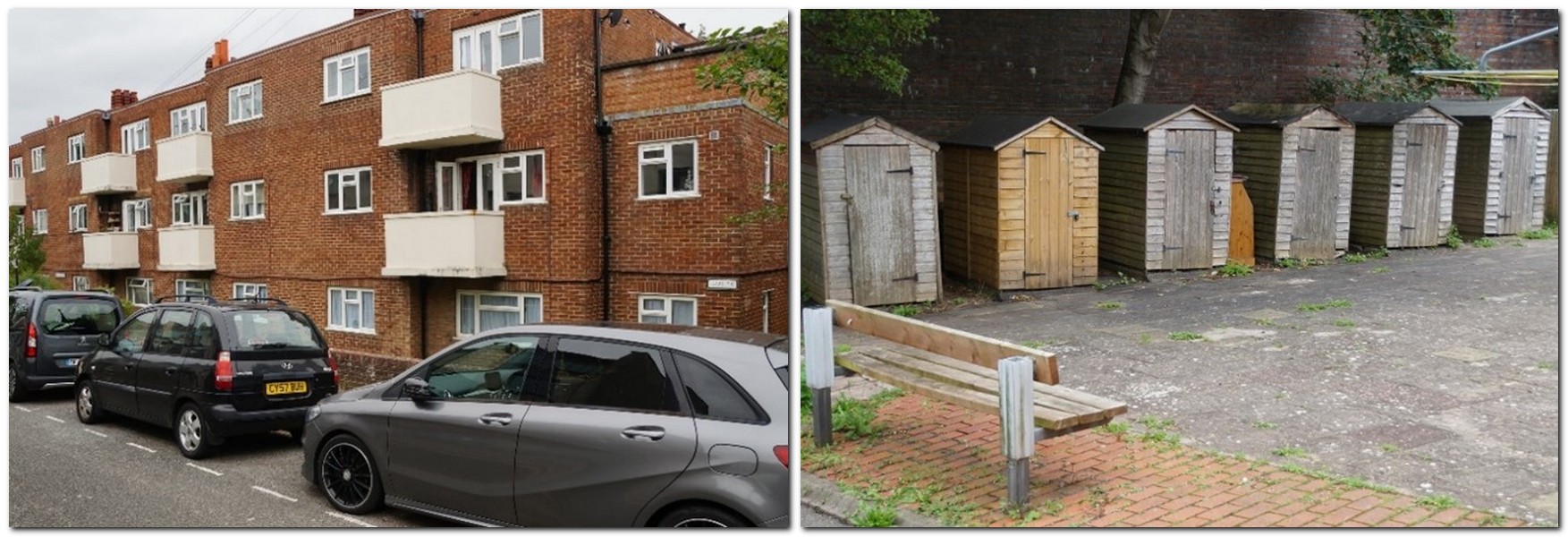
South Place flats, and the sheds built against the Naval prison wall
South Place, and the Priory Flats in Southover completed a couple of years later, are typical of 1930s slum clearance schemes nationally. Building higher at greater density was increasingly being seen as the solution to the problem of how to make rents affordable for lower-paid workers, whom councils were now obliged to re-house. South Place is typical too of councils’ initial attempts to keep people living in the communities they had vacated. Town-centre redevelopment of this kind was confined to relatively small schemes, however. The need to re-house was so great that the vast majority of new homes were built on new estates, mostly located on the outskirts. Lewes Borough Council was soon in negotiation to purchase the land required for much larger-scale projects at Winterbourne and Landport.
Sources: Lewes Borough Council Sanitary & Housing Joint Committee minutes ESRO DL/D/174/1; 1934 Sussex Express
- Green tiles on the Red, White and Blue (by Dee O’Connell)
Re the green ceramic tiles on the Red, White and Blue public house (Bulletin no. 151), I have noticed that other Portsmouth & Brighton United Breweries pubs in Brighton also have the same green tiles, Maybe they added their own branding but kept the name Red, White and Blue when they took it over from the Rock Brewery.
- The cause of the 2000 Flood (by John Warner)
I very much enjoyed the January talk by Marcus Taylor but would like to correct the unfortunate rumour remaining in circulation that the 2000 floods were caused by incorrect operation of the flood gates at Barcombe Mills. This was raised in the questions. The speaker tried to deal with it but unfortunately the last message on the question board was that a Southern Water Engineer had stated that the splitting of operations had led to communication problems and inadequate operation of the Barcombe Mills flood gates. I did post a reply but it was not picked up before the meeting was closed.
I worked for the Environment Agency in 2000 and can assure you this is simply not true. The weirs at Barcombe Mills had been fully open for several weeks prior to the October Floods to convey the high flow of river water through the catchment. I was in the Environment Agency control room and at the Lewes District Council emergency response meetings dealing with the flooding, so I know at first hand that Lindsay Frost is correct, there was no human error. The official flood report, by reliable professional flood consultants Black and Veatch confirms this.
It is the Environment Agency that coordinates the operation of the Barcombe gates and all of the control structures on the main river Ouse. Southern Water are in charge only of the sewage treatment works and the urban sewers that take foul waters away. Please communicate these views to the talks’ audience, so they are left with an accurate record of facts for the causes of the Lewes Floods, rather than the incorrect rumours of Floodgates being opened and human error.
Sadly Lewes will flood again. Climate change, rising sea levels and increased rainfall mean that inevitably the volumes of water in the Rivers Ouse and Uck will one day increase to a point when current defences will become overwhelmed and Lewes & Uckfield both flood.
John Kay
Contact details for Friends of the Lewes History Group promoting local historical events:
Sussex Archaeological Society
Lewes Priory Trust
Lewes Archaeological Group
Friends of Lewes