Text: Jill Goulder
Photographs: John Downie
In the archives of The Keep at Falmer is a 3-D model (at a scale of 1:1250, and more than 5 ft long, made c.1962) of how Lewes would have looked if a startling 1960s proposal for the ‘Lewes Inner Relief Road’ had gone through.
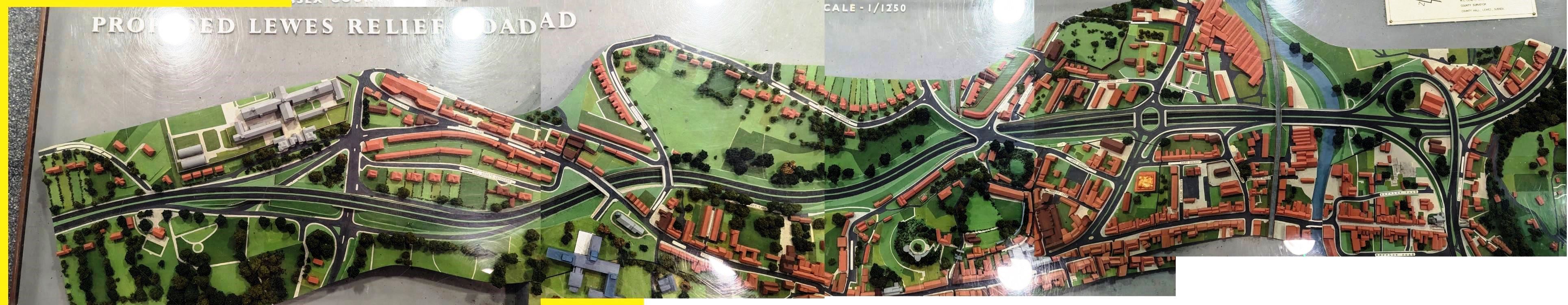
Lewes Inner Relief Road model, West to East, composite photo. Click to enlarge. Warning: light reflection due to acrylic cover
The proposed road would have sawn Lewes in half. Looking at the model from east to west, the route came north up through South Street, widening to a dual carriageway near the chip shop and taking out houses on the west side, with a service road to Cliffe bridge via Rusbridge Lane. Cliffe High Street was to be pedestrianised. The route continued north, scraping past the east wall of St Thomas à Becket with more houses gone, with an underpass enabling residents and walkers to cross from St Thomas to Chapel Hill.

South Street
The route then split into a looping junction, east up Malling Hill and west to a new bridge across the Ouse: the Phoenix causeway. The causeway was the only part of the scheme to be built in the end, and which as a 1973 Country Life article comments ‘at present gets traffic all the quicker into the bottlenecks’. The model of course includes the Uckfield rail line, curving through the present Tesco site and crossing the Ouse north of the Phoenix bridge and on through the present precinct.

Junction with North Street, Market Street, and Little East Street, composite photo.
Click to enlarge
The dual carriageway was to run west up Little East Street, ducking under a very large raised gyratory system from which North Street and Market Street (the latter two-lane) went north and south. It is then shown as continuing into a cutting, taking out Mount Place and White Hill, and slicing through the top ends of St John Street, Sun Street and Abinger Place (and eliminating the Elephant and Castle pub) to dive under another raised gyratory serving Paddock Road, Offham Road and St John’s Terrace.
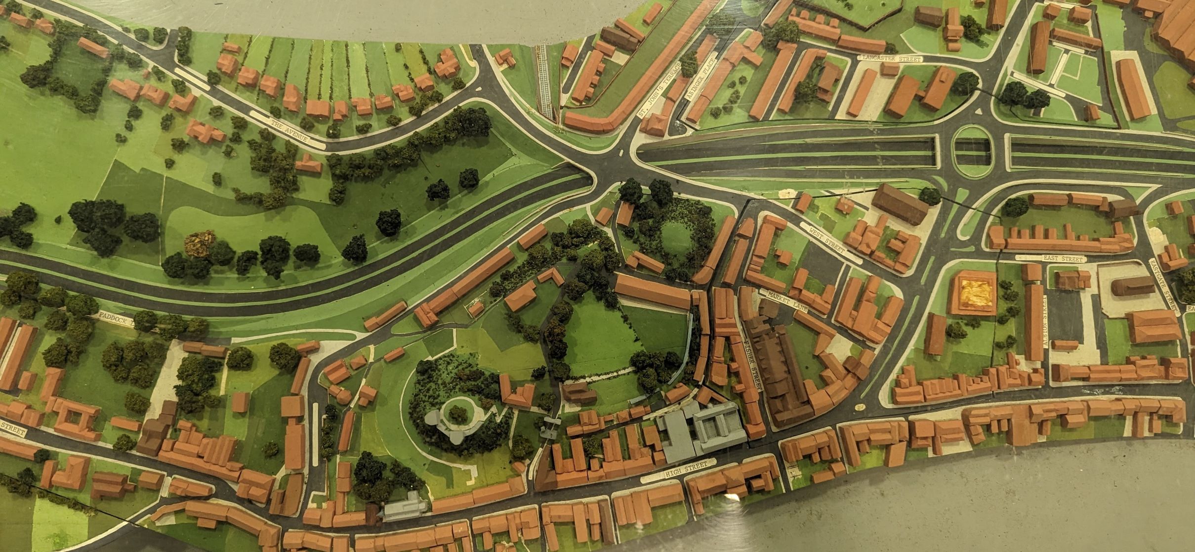
Aerial gyratories at North and Market Streets, and Elephant and Castle pub site
Click to enlarge
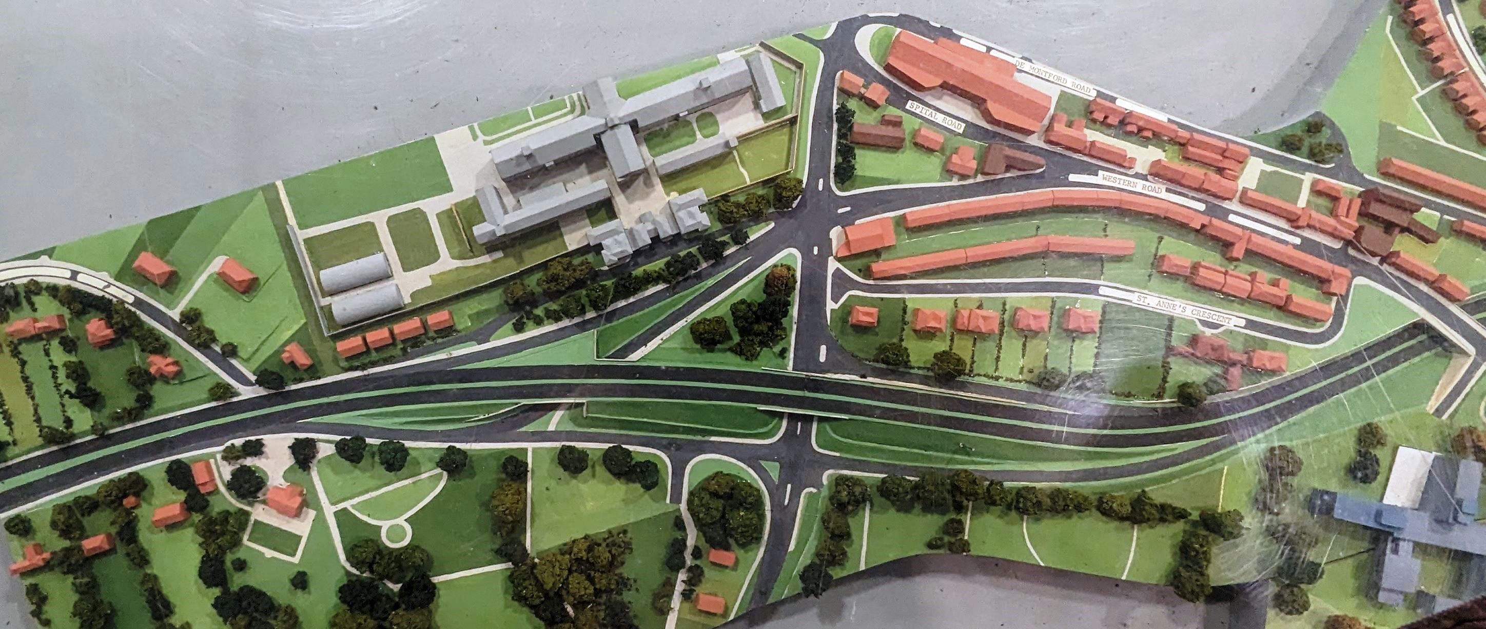
The dual carriageway then curved west to run through the south side of the Paddock and Baxter’s Field on a large embankment, then under a bridge carrying Bradford Road, slicing through de Montfort Road and into a cutting under Western Road next to St Anne’s Church.

Aerial gyratory above Elephant and Castle site, embankment in the Paddock/Baxter’s Field, cutting under Bradford Road and Western Road by St Anne’s Church
Click to enlarge
The proposed route then curved west on an embankment through the cemetery, parallel with St Anne’s Crescent, branching into multiple slip roads serving this complex junction area and bridging the top end of Winterbourne Hollow south of the existing prison crossroads to merge with the Brighton Road.
A new junction under this bridged area, just to the south of it, fed new slip roads, for example west and north to join the dual carriageway opposite Southdown Avenue, and east and north to join the High Street.
The prison crossroads seem to remain apart from a new south-west slip road going under the main dual carriageway and cutting through Warren Drive and round to join the slip road to it.
St Anne’s Crescent, cemetery, Winterbourne Hollow, prison, Brighton Road. Click to enlarge
The model illustrates dramatically how the scheme’s core aim of protecting School Hill and the High Street – and relieving congestion in Cliffe High Street – would have entailed the sacrifice of large tracts of central Lewes, including demolition of nearly 100 buildings of importance, almost one-third of them listed.
All pedestrian access between the two halves of Lewes would have been via footbridges and underpasses: as Peter Linklater (Chair of the Friends of Lewes) said in a meeting in circa 1967, the road would have constituted ‘a major psychological barrier’ as well as a physical one.
As realisation of the threat grew in the later 1960s the national media took an interest, which assisted in prompting the Ministry of Transport to authorise a report, ‘Traffic in Lewes’, in 1969. This recommended a southern bypass, which we now have. Spirited protests in the early 1970s – Lewes showing its teeth – fortunately quelled the Inner Relief Road project, and also the South Street and Malling Street ‘improvement’. In the end the Phoenix Causeway, (and separately the Cuilfail tunnel), was the only section built.
There is more in the archives on the various other options proposed for Lewes and the A27 and A26 routes; but this short piece presents – for the first time – a photographic record of the 3-D representation of what we so nearly had.
Sources
This is a very selective summary, to accompany the model photos; more details of the complexities (notably the issue of the South Street/Malling Street route) are available in various publications and documents.
Nicholas Taylor: £3m New Road May Cut Lewes in Two, newspaper article found in Lewes Library, publication unknown, c.1967. (Contains Linklater quote)
Keith Spence: The New Battle of Lewes, Country Life, 29 Nov 1973, p1783-84.
Friends of Lewes Society: Lewes 1952-2002: Fifty Years of Change, 2004.
(This was a major source, and is available from Lewes library)
John Downie – photographs of the model
Heather Downie – material from Lewes History Group sources
The Keep Archive Centre at Falmer
Details of the model
Creator: East Sussex County Council
Title: Three-dimensional Model of Proposed Lewes Relief Road
Scale: 1:1250
Date: c.1962
Orientation: WSW to ENE, from Brighton Road to Malling Street
Names on label: L.S. Jay, County Planning Officer; M.C. Leney, County Surveyor
Keep archive no.: C/R/16/1/1
Please do not contact The Keep and ask to see the model
It is in the archives and is very heavy, fragile and difficult to get out. If there is interest, it might be possible to approach The Keep about a one-off group visit.