The Riverdale Street Story, by Barbara Merchant (March 2015)
An introduction
Riverdale is a small development of four modern houses built on a slope on the Sussex Downs running down to the banks of the River Ouse in Lewes. Almost hidden from view, the houses are approached via a small gap in the hedge along an unmade lane, which leads on to the historic South Malling Church, and the impressively grand Malling Deanery. Upon turning into Riverdale, a drive winds through attractive parkland dotted with trees. The houses are at the bottom of the drive, and beyond them lie the gardens.
Two of the gardens are enclosed together by a wall on three sides, built of brick and topped by sweeping scalloped steps as the walls descend down the slope towards the river. Midway are two graceful brick and tile gazebos, crowned with ball finials, along with the remains of a whitewashed wall. Arched gates lead out of the walled enclosure into a secluded water garden, bordered by fruit trees, irises, roses, and weeping willows. This is ancient brookland, creatively managed by the planting of trees, and protected by an old dyke. With the high tide, the River Ouse flows in, filling an ancient drainage cut.

Water garden in early spring at very high tide, ©Neil Merchant
These magical gardens have been wrestled into being only since 1978. Inside the garden wall, the first owner Susan Crossett recalls, “was a blank area of compacted soil with not a plant or greenhouse. The garden wall was completely obscured by elder and ivy, beneath which the structure had lost much of its mortar and was in many places see-through. Beyond the wall, through a jagged hole, the rest was just brambles and thicket through which the builder said ‘I believe you can beat a way to the river’. There was of course no sweet rose garden and water garden!“1
So, what had been here before? A rose garden, and a water garden? Why was there a walled enclosure, with its gazebos and whitewashed wall? And what exactly were those arches under the patio of our house?
Uncovering the mystery
The first indication that the walled enclosure had been a substantial kitchen garden came when Tom Petherick of the Lost Gardens of Heligan suggested that the arches under the patio pointed to the presence of a former vinery. The arches allowed the roots of the vines to extend into the cool soil outside of the hothouse.2 It would appear that our house had been built partially on the hard standing of a large hothouse.
This find was followed by extensive historical research. Our house Deeds indicated that Riverdale had been part of the Malling Deanery estate, dating back to 1623. A reading of the secondary sources, and discussions with History Group members and neighbours led me to the Library of the Sussex Archaeological Society. There I found a wealth of primary resources, such as the Deeds and associated documents for Malling Deanery. From these, and the collections of the East Sussex Records Office, Lewes Library, newspaper archives, and the Lewes District Council planning records, I have managed to uncover the story of Riverdale and its gardens, and have discovered some intriguing stories about Malling Deanery along the way.
Early records
One of the earliest mentions that I have found of the area now called Riverdale is on a map dated 1622. This is titled “An Exact and Perfect Survey of South Mallinge in Y County of Sussex, being Parcell of the Possessions of Y Right Honorable Richard Earle of Dorset. 1622. By Jo. DeWard Surveyors”3

Survey of South Mallinge…. by John DeWard, 1622 (detail). By kind permission of Sussex Archaeological Society, Barbican House Museum
This detailed section of the intricate and beautiful drawing shows the ruins of a church, set north of a large house and outbuildings, all surrounded by fields, brooks, and what looks like very ordered gardens planted in regular beds, and regiments of trees. A valuation of the estate, clearly linked to this map but found in another publication, states: “The Rectorie or Mansion house is fairlie and stronglie built and all offices thereunto belonging with two stables three barnes one gatehouse and one Dove house. Also the scite containeth of three gardens two orchards and one Court.”4 To the east, and running the length of the land north to south, from the level of the Church down to the river, is an area marked Greene Croft Meadow. Near the bottom of the meadow is a familiar drainage cut, and between this and the river, is a planting of trees. The valuation document describes this as land “In Meadow” with an area given as 2-0-5 (2 acres, 0 roods, 5 perches). Could Green Croft Meadow have been the early Riverdale?
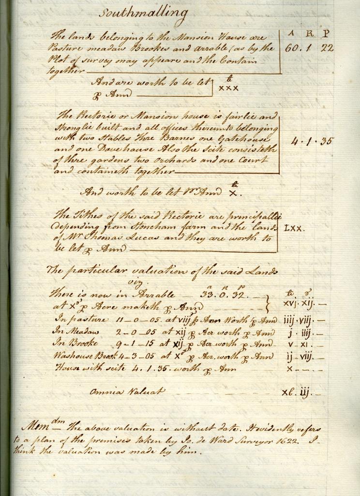
Valuation of Malling Deanery, attrib. John DeWard 1622. Woollgar’s Spicilegia Vol. II.
By kind permission of Sussex Archaeological Society, Barbican House Museum.
The estate depicted on the map is that of Malling Deanery, in South Malling, Sussex. Early evidence suggests that there was a monastery at Old Malling, although its exact history is uncertain, it being rebuilt and possibly resited later. The monastery later became the College of the Benedictine Canons at South Malling. In about 1515 Archbishop Warham directed that “a portion of land belonging to the archbishops…to be set out, near the churchyard, sufficient for the erection of a suitable manse…” to be built to provide accommodation for the sacrist and vicars who accompanied the canons when they were in residence at the Collegiate Church of South Malling.5 It is likely that the manse was the early Malling Deanery, which contains traces of early 16th Century architecture, and which is sited close to the current Church of South Malling: itself generally accepted as being built on the site of the medieval church.6
Mr. Serjeant Kempe, the owner of the estate from the 1760s until his death in 1779, wrote that “…. the ancient fish ponds within the bank of the river, which were more than half grown up with mud, have been every where filled up by the present possessor. The old part of the present capital messuage and the walls to the South and West of it, and the Dove-house are part of the old Deanery, as appears by Draughts on ancient maps”.7
Kempe may well have been referring to the deWard map, but there are no fish ponds on this map, unless he meant the drainage cut situated in Green Croft Meadow. However, as we will see on a succession of later maps, this cut has largely remained unchanged since 1622.
We will also see how Green Croft Meadow evolved to become today’s Riverdale, which was formed of Green Croft, and part of the land to the East labelled Scotson. For the moment, this overlay of the 1622 deWard map onto Google Earth shows Green Croft Meadow forming a good half of the land which was to become Riverdale.

DeWard 1622 map overlaid on Google Earth, overlay ©Barbara Merchant
A family home
During the dissolution of the monasteries in 1545, South Malling College surrendered to the Crown. In 1590, Queen Elizabeth granted to Thomas Sackville, Lord Buckhurst, and later the 1st Earl of Dorset, the lands, mansion, rectory and church which had belonged to the College.8
It is likely that the beautiful map was drawn up for the sale of the estate by Richard, the 3rd Earl of Dorset. In 1623, John Stansfield of Cliffe bought the estate for £700.9 Stansfield was a highly successful merchant, whose shipping business operated from Newhaven. He found the church in a ruinous state, and had it rebuilt. His grandson, the diarist John Evelyn, laid one of the first stones of the new church, which still stands today.10
In 1648, Evelyn sold the Malling Deanery estate to its occupier, William Kempe of South Malling. 11 The property was then held by five generations of the Kempe family, including Dr Richard Russell, who became famous for his seawater cures and the associated development of Brighton as a seaside resort.12
After Mr Serjeant Kempe’s death, parts of the Malling Deanery estate were advertised for sale by auction in 16 lots, at the Star Inn in Lewes, on Saturday 8th of March 1800.13

Top section of advertisement for the sale of part of Mr. Serjeant Kempe’s estate. Sussex Advertiser, Monday 3 March 1800, page 1
Thomas Budgen made a map for the sale, titled “A Sketch of Property in the Parishes of South Malling and St. John Under the Castle of Lewes belonging to the late Mr. Sergeant Kemp”.14

Thomas Budgen’s sketch of the late Mr. Sergeant Kemp’s property, 1800 (detail).
By kind permission of Sussex Archaeological Society, Barbican House Museum
The two areas marked C on the map form part of Lot 1, described as “the Western part of Dog Kennel Field”. This is clearly Green Croft Meadow with the addition of part of Scotson’s land, and is essentially today’s Riverdale. Its area is given as 4A 0R 12P, which is what Riverdale would have been today but for the railway cutting, of which more below.
The very ordered kitchen(?) gardens between the Deanery and the river have been replaced by fashionable lawns, trees, plantings, watercourses, and a laid out walk. The Kempes had acquired land to the east from Scotson (marked F, G, H), and moved the kitchen gardens out of sight to G, the site of the current Glebe Cottage gardens and stables.
The water courses by the river showing on the areas marked A on the 1800 map were most likely created by the Kempes, for they were not shown on the 1622 deWard map. They seemed to have served a decorative purpose, and were gradually reduced over time until disappearing by 1908.15
The Campions and Courthopes
The Deanery buildings, gardens, and Dog Kennel Field were bought by a series of property developers, and rented out, until Henry Campion purchased the building and various brooks and fields in 1811, followed by Dog Kennel Field and the rest of the old Scotson land in 1824.16
The maps for this sale show how Campion bought the North-Western corner of Dog Kennel Field in 1811, followed by the rest of it in 1824:
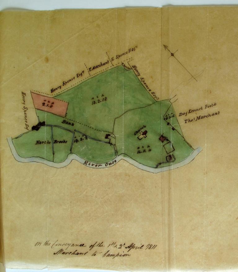
On the Conveyance of the 1st & 2nd April 1811 Marchant to Campion. By kind permission of Sussex Archaeological Society, Barbican House Museum

On the Conveyance of 4th August 1824 Marchant to Campion. By kind permission of Sussex Archaeological Society, Barbican House Museum
The Deanery came into the ownership of the Courthope family in 1836 via Henry Campion’s sister Amelia, who was married to George Courthope. The Courthopes put the estate up for sale by auction in London on 23 June 1857. By now the estate had grown to encompass the entire piece of land enclosed within a loop of the River Ouse, totalling about 180 acres, and included the farmland previously owned by the Spence family. The old Scotson land labelled 2, 3, and 4 above appear to have been sold off, and the brooks south of the River Ouse in St John’s parish are not listed.
The mansion house was described as “a most substantially built family residence, with offices, stabling and coach-houses, pleasure grounds, small well-timbered park, with a rookery”. There is “a yard behind, with out-offices, and a large walled kitchen garden. Adjoining the house is a paddock, at the lower end of which is the stabling, comprising a detached brick building, containing three stalls, and three loose boxes, carriage house, and cow stall, with lofts or men’s rooms over the whole.”
“The pleasure grounds are tastefully disposed in lawns, shrubberies, and serpentine gravel walks, with a terrace by the river side, the whole ornamented by a profusion of choice American and other shrubs of luxuriant growth. There is also a fine old rookery. The house and grounds are completely surrounded by the meadows, through which is the carriage drive; this is also the public way to the Church, in which are two pews appropriated to the estate.”17

The Malling Deanery Estate, Lewes, Sussex, for sale 1857 (detail). By kind permission of Sussex Archaeological Society, Barbican House Museum
Solicitor Edmund Charles Currey bought the parts of the estate marked A and B in red on the map 18 above in April 1859, and the farmland was put back on sale. The meadows marked B and A*are clearly the early Riverdale, showing the drainage cut, and now also a dyke parallel with the river stretching its width and beyond.
The Railway sale
In 1864, the London, Brighton and South Coast Railway obtained authorisation to build a new line from Uckfield to Lewes. This was heavily engineered, requiring embankments and bridges such as those at Malling. A draft conveyance of 22 December 1865 shows land in the Parish of Malling being sold by E.C. Currey to the London, Brighton & South East Railway Company for the Lewes and Uckfield Junction Railway.19 Currey received £2,250 for the sale of the section of the ‘Riverdale’ meadow labelled 21, part of his access road: 22, pasture north of his road: 23, and a tree plantation: 24. The overlaid map below shows the extent of the land sold to railway company. The company agreed to build a brick bridge with shore piers and caps over the cutting, and the embankment was to be turfed. This section of the railway opened on 1 October 1868.

BLSCR 1865 drawing (by kind permission of Sussex Archaeological Society, Barbican House Museum ) overlaid on Google Earth, overlay ©Barbara Merchant
The new walled garden
The Curreys lived at Malling Deanery, barring a brief absence in 1891-92, until they sold the estate to William Wainwright in July 1903 for £3,750. One year later, Wainwright sold it on for £6,850.20
The new owner was a young gentleman named Andrew Duncan Macneill. Macneill embarked on a building spree, putting up the Deanery Cottages,21 and a number of farm buildings such as a small dairy. By 1908, an Ordnance Survey map (below) shows that he had built the New Garden in the ‘Riverdale’ meadow: a walled kitchen garden, divided into 2 sections, containing 4 large hothouses, and two brick and tile potting and tool sheds.22 A path led to this garden from the access road to the Deanery and South Malling Church, just past the bridge over the railway cutting.

Ordnance Survey map revised 1908 showing walled kitchen garden in Malling Deanery’s grounds, Lewes Library. © Crown Copyright. Reproduced by permission of Ordnance Survey
A fruit store added to the outside of the walled kitchen garden was also drawn onto the OS map. The plans for this fruit store illustrate the scalloped steps of the garden wall rather beautifully:

Plans for a fruit store, by W.F. Ingram & Son, Surveyors, Lewes. By kind permission of East Sussex Records Office23
An Edward Reeves photo dated 1909 (negative number 882) confirms the existence of the newly built walled garden and the large hothouses.
Mr Henry Cook was head gardener at the Deanery at this time, and at the 1911 Census he lived with his wife and son in the Deanery Cottages. He provided floral decorations for South Malling Church, and won numerous prizes at the Lewes and District Chrysanthemum Society Shows, including first prize for “Three bunches of grapes, black”24.
He remained as head gardener under Colonel Alan Richardson, who bought just the house and garden lot out of the 60 acre Malling Deanery estate in July 1912,25 followed by Bridge Brook across the river in October 1912.26 In November 1912, there were four gardeners at Malling Deanery working under Mr Cook.27
By 1917, Henry Cook had very likely retired, and with the war on, Colonel Alan Richardson, now the commander of the Lewes Volunteer Training Corps for Home Defence, “…asked for the conditional exemption of Mr M.L. Haffenden, 28, B1, whom he explained was his only gardener, on about ¾ of an acre of kitchen garden, from which vegetables were sold.”28

Mr Mark Haffenden, of Deanery Cottages. Courtesy of Ruth Paull-Wills, granddaughter
The Sanderson Years
Brewery magnate Thomas Sackville Manning owned the Deanery for about a year before selling it on 28 July 1920 to Sir Frank Sanderson, Baronet, businessman and later a Member of Parliament.29 The Sandersons were generous supporters of South Malling Church, and in 1928 they gave a piece of land adjoining the Vicarage on Church Lane, recently used by the vicar as a kitchen garden, to the parish as a gift to celebrate the tercentenary of the current church.30 The land was the top right corner of ‘Riverdale’ which had been sliced off by the railway cutting in the late 1860s. Much later, the Church authorities built a new vicarage on this site, and sold the old vicarage in December 1981.31
The Deanery gardens thrived during the Sanderson years. Mrs Sanderson was President of the Lewes and District Horticultural Society, and her gardeners Mr G.T. Wren, and Mr Maurice Carter were regular competition winners.32 Lady Sanderson died in 1949, and Sir Frank sold the property in early 1951. The Hampton & Sons sales brochure describe “The old-world grounds [as] being in immaculate order, and possess a charm which age alone can give”. It goes on to describe the “two walled kitchen gardens with two brick and tile potting and tool sheds, and glass as follows: Vinery with thirteen vines, Peach and nectarine house, glasshouse with 3 divisions and another with 2. There is also an Orchard.”33
An aerial photo taken two years previously shows clearly the 4 hothouses in the walled kitchen garden and the orchard:

Detail from an aerial photo showing the Malling Deanery walled kitchen garden, 1949. Britain from Above, © English Heritage www.britainfromabove.org.uk/image/eaw024777
Also in the photo are the railway cutting and bridge, and the river Ouse at the bottom of the picture. In between the hothouses are rows of crops, and the hothouse at top left even has 13 glass planes, one for each of the 13 vines.
Panning out, we can see the walled kitchen garden in context within the grounds of Malling Deanery. The spire of South Malling Church is just visible North-West of the house.

Detail of an aerial photo showing the Malling Deanery and its walled kitchen garden, 1949. Britain from Above, © English Heritage www.britainfromabove.org.uk/image/eaw024777
The Hampton brochure goes on to describe the area between the walled kitchen garden and the river, where there is “A fish pond with old bridge, overlooked by a grass terrace with iris border and rose garden, woodland walk by the river, the whole being richly embellished by some fine timber and ornamental trees.”
This is the accompanying photo:
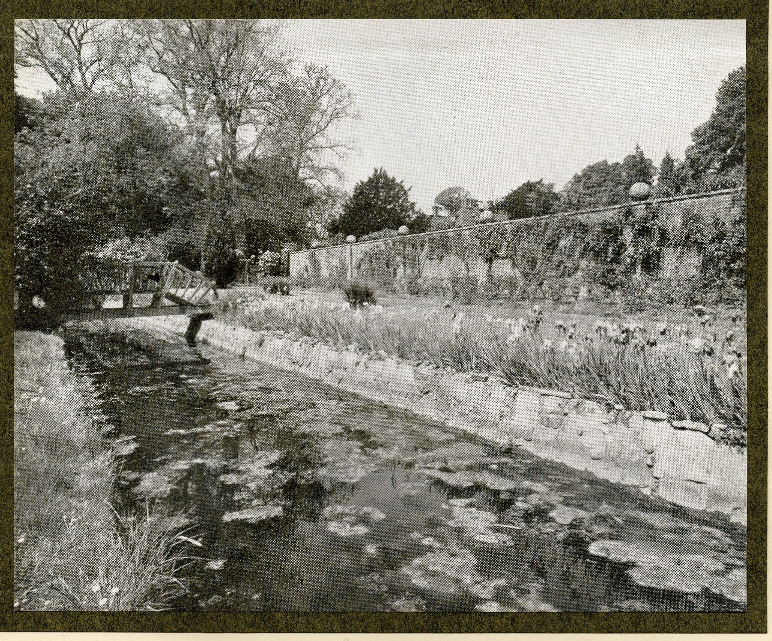
Photo of the Malling Deanery water and rose garden, Hampton & Sons sale brochure c. 1950. By kind permission of Sussex Archaeological Society, Barbican House Museum
At last, we have found the “sweet rose garden and water garden” which the Sandersons had described to Susan Crossett.
We can see the Sanderson family enjoying this charming spot in a slightly earlier photo: the grandchildren are boating in the water garden, while their parents look on from the wooden bridge.

Image kindly provided by Johnny Coburn, © Sanderson family
The question now is: however did this idyllic garden fall into rack and ruin, turning into a wasteland covered in brambles and thicket?
Dismantling the estate
Wine importer and hotel owner Robert Lamdin and his family bought the Malling Deanery estate from Sir Frank Sanderson in 1951. In the following years, Lamdin tried repeatedly to obtain planning permission to develop the grounds for housing, but was unsuccessful.
In early 1969, the Lamdins put the now Grade II* listed mansion and its 30 acre estate on the market. Meanwhile, Lewes-Uckfield railway line was closed down in May 1969.

Rowland Gorringe advertisement in Country Life, 25 September 1969
Lewes Borough Council considered purchasing the estate for Lewes, with the intension of possibly converting it into a home for the elderly, which would be surrounded by public space.34

Plan CP117 of Malling Deanery from Register of Local Land Charge, ESRO35 © Crown Copyright. Reproduced by permission of Ordnance Survey
While they deliberated however, the developer Vilshire Properties Limited stepped in and bought the estate in November 1969. Vilshire offered to sell the mansion on to the Council, as it would have been less profitable to develop than the brookland south of the river, the fields surrounding South Malling Church, or the one containing the walled kitchen garden. They intimated that this transaction would be subject to confirmation from the Council regarding Vilshire’s future residential use of various fields retained, and industrial use of the land south of the river. Plus there was the issue of right-of-way over Council land to access the proposed industrial area south of the river. As this was not forthcoming, Vilshire put the property back on the market.36
The Rowland Gorringe description of the property, most likely for this sale, offers the estate as a whole or in 8 lots. Lot 7 is described as “The Farmery and Walled Kitchen Gardens. This interesting lot is situated well away from the main residence on the extreme eastern side of the property with its own separate access off Church Lane. It is considered that this lot has considerable potential for development as a small holding or market garden business lying in a sheltered and sunny position with existing Piggery buildings and concrete yards. The existing buildings comprise:-
Purpose built concrete framed and asbestos Piggery, about 36’ x 27’ overall
A pair of brick and a pair of concrete Farrowing Pens. Open Store about 18’ x 12’ with asbestos roof
A North Walled Garden enclosed by a substantial brick wall and containing two large greenhouses on brick plinths, approximately 60’ x 18’ and 60’ x 12’.
The South Walled Garden enclosed by a high brick wall and containing two lean-to Glass Houses, about 50’ x 9’ and 60’ x 9’. Attached to the walled gardens on the East side are 2 useful brick and tile Store Buildings.
NOTE Outline application has been made…for erection of a dwelling house…to be used in connection with a Smallholding or Market Garden.
Alternatively the walled garden would provide ideal sites for the erection of one individual unit within each garden, subject to outline Planning Permission.”37
This 1970 Land Registry map shows the walled garden with glasshouses, and the piggery buildings and yards. These are at the top of the drawing:

Title plan for part of the Malling Deanery estate, H.M. Land Registry, 1970
© Crown Copyright. Reproduced by permission of Ordnance Survey
By 10 February 1970, Lewes Developments Limited had bought the entire estate from Vilshire, and in their turn intended to offload the main house, stables, and cottages. These were bought in September 1970 by yet another developer, Jack Stafford.38 He sold the Deanery Cottages, and divided the Deanery building into three wings, and sold them on with their gardens in 1972. Other buildings were converted and sold on as The Coach House, and The River House.39
Development of Riverdale
Meanwhile, the “Riverdale” land deemed to have more development potential was subjected to numerous refused planning applications, before approval was obtained in 1975 for the restoration of the existing walled kitchen garden and gazebos and erection of four residences.40 It is likely that at this point, Lewes Developments Limited sold all the development land on to Bighill Construction Limited. Further planning applications followed for the walled garden plot, all refused until Jenner and Windsor (Builders) gained approval for the erection of four detached dwellings on 3 June 1977.41
Bighill sold this plot to Jenner and Windsor Limited of Lewes on 30 June 1977,42 and they proceeded to build the current 4 houses on the plot, which would be named Riverdale.
By now, after 8 years of being passed from one developer to another, the walled kitchen garden and the farmery had fallen into a state of disrepair, and the rose and water gardens had disappeared under a mass of brambles. Sharon Reid remembers:
“Where Riverdale is, there used to be a large field next to the railway line which ran down to the river which had a tin barn, [a local resident] kept her horses there. The other part was the walled garden of the Deanery. It had an old iron gate which we would sneak in through, hoping we didn’t get caught by [her]. It was very overgrown but you could get around on the paths. There were broken greenhouses and potting sheds with taps for water, we spent hours playing in there. It was rather lovely, shame it’s gone, especially when you watch people restoring old Victorian walled gardens on TV.”43
Susan Crossett described what happened next:
“The builder bulldozed the middle wall half way down the garden in order to build a septic tank and drainage field. He left piles of bricks and rubble all over the place, didn’t break the pieces of wall, just bulldozed them into the ground along with stacks of glass and metal. I discovered the bricks and mortar stuck in great lumps below the soil, cleaned off the mortar and used them to build brick paths and circles.”44
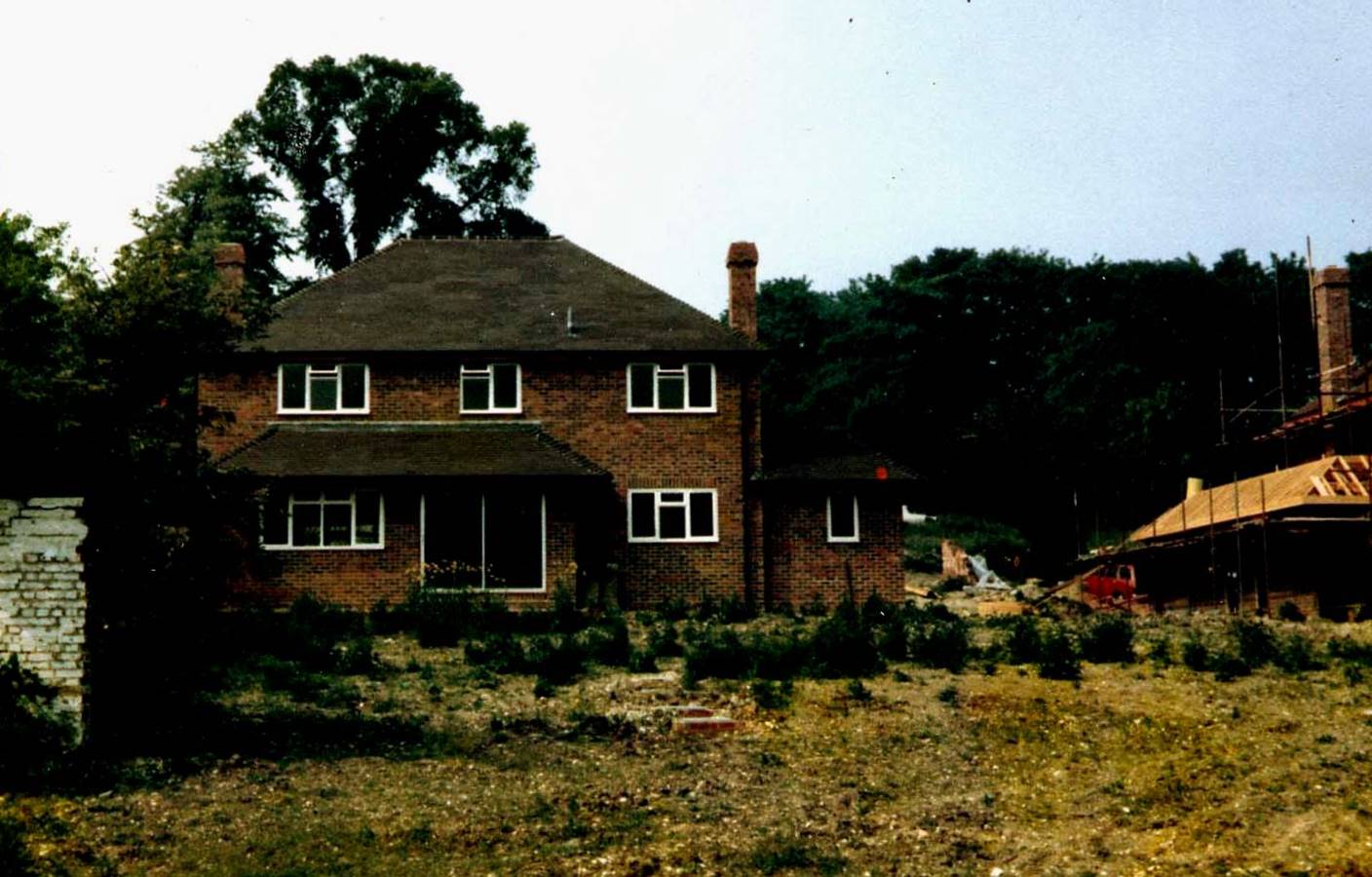
No. 1 Riverdale, September 1978, photo courtesy of the Crossett family
The builder bricked up the gateways into the walled garden (on the east and west walls) using new unmatching bricks, and punched jagged holes into the south wall to provide a way through to the river. The arched gateways were added later.
Finally, Number 1 Riverdale was completed, and sold to the Crossetts in September 1978.45 The other three houses in the development were built in sequence, and number 4 Riverdale was sold to its first owners in April 1979.46 Numbers 1 and 2 were positioned such that they formed the northern boundary of the old walled garden, with their gardens enclosed within the remaining three walls, and extending beyond the Southern wall to the river. Numbers 3 and 4 were built outside the walled garden on the site of the old piggery. The ownership of the land from Church Lane down to the river is divided between the 4 houses.
Meanwhile, the lady who had been keeping her horses on Riverdale bought the paddock land surrounding South Malling Church from Bighill Construction in April 1978.47 There appear to have been no planning applications submitted for the development of this land since a refusal in 1970. However, it was a different story for the last piece of development land: the holding across the river. For over a decade, the various developers applied to turn this low lying land first into an industrial area, then for warehousing, then recreation, followed by a sport and nature conservation area, all unsuccessfully. This was no doubt due to the difficulty in raising its level by controlled dumping, access problems, and because it was designated on the Town Map as public open space. It was last sold on in 2007.
And how has Riverdale fared in the last 35 years? Perhaps this can be illustrated in a sequence of photographs:
Garden design, construction, and planting by the Crossett family.
All images © Neil Merchant
Acknowledgements
I would like to thank John Kay, John Bleach, Colin Brent, Ann Holmes, Dee O’Connell, Esme Evans and Emma O’Connor and their staff at the Sussex Archaeological Society library and museum, staff at ESRO and Lewes Library, Susan Crossett, my neighbours, Johnny Coburn, Sharon Reid, Ruth Paull-Wills and other members of the Lewes Past Facebook Group for all their help in the preparation of this article.
References
- Crossett, Susan, Personal communication 25 Feb 2012 ↩
- Petherick, Tom, Personal communication 19 Jun 2009 ↩
- DeWard, John, An Exact and Perfect Survey of South Mallinge in Y County of Sussex, being Parcell of the Possessions of Y Right Honorable Richard Earle of Dorset, 1622. In: South Malling 1703-1951, Manuscript volume held at the Sussex Archaeological Society Library ↩
- Woollgar, Thomas, attributed to John DeWard, 1622, Southmalling: Valuation of Malling Deanery. In: Woollgar T, Spicilegia sive Collectanea ad Historiam et Antiquitates Municipii et Viciniae Lewensis. II, p. 441. Early 19th century manuscript volume in the Sussex Archaeological Society Library ↩
- Turner, Edward (1852) The College of Benedictine Canons at South Malling, Sussex Archaeological Collections, Vol. 5, pp. 127-142 (pp. 136-7) and (p. 141) ↩
- Ladipo, Sue (2002) A History of Saint Michael the Archangel – the Parish Church of South Malling, South Malling Parish Church, p. 9 ↩
- Kempe, William (ND) In: Woollgar T, Spicilegia sive Collectanea ad Historiam et Antiquitates Municipii et Viciniae Lewensis. II, pp. 142-149. Early 19th century manuscript volume in the Sussex Archaeological Society Library, and reproduced in Horsfield, T.W. (1827) Malling, South, History and Antiquities of Lewes and its Vicinity, Vol. 2, J. Baxter, pp. 164-172 ↩
- ibid., Horsfield p. 169 ↩
- Woollgar, Thomas(ND), Spicilegia sive Collectanea ad Historiam et Antiquitates Municipii et Viciniae Lewensis. II. p. 442. Early 19th century manuscript volume in the Sussex Archaeological Society Library ↩
- Horsfield, T.W. (1824) History and Antiquities of Lewes and its Vicinity, Vol. 1, J. Baxter, p. 332. ↩
- Brent, Colin (2004) Pre-Georgian Lewes, c.890-1714: the Emergence of a County Town, Colin Brent Books, p. 420 ↩
- List of owners of Malling Deanery since the Dissolution. In: South Malling 1703-1951, Manuscript volume held at the Sussex Archaeological Society Library, p.13 ↩
- Particulars and conditions of sale of several parts of the real estate of the late Mr Serjeant Kempe which have been advertised for sale by auction, at the Star Inn in Lewes, on Saturday 8th of March 1800. ESRO ACC5500/1/1. Also: Sussex Advertiser, Monday 3 March 1800, p. 1 ↩
- A Sketch of the property in the Parishes of South Malling and St John Under the Castle of Lewes belonging to the Late Mr Sergeant Kemp, by Thomas Budgen in 1800. In: South Malling 1703-1951, Manuscript volume held at the Sussex Archaeological Society Library. ↩
- Ordnance Survey map of St. John Under the Castle, Lewes, surveyed 1873, revised 1908, published 1910 ↩
- Deeds and maps of 1,2 April 1811, and 4 August 1824, showing sale of property by Thomas Marchant to Henry Campion. In: South Malling 1703-1951, Manuscript volume held at the Sussex Archaeological Society Library ↩
- Malling Deanery, farm and land (177a 39p) in South Malling (plan) for sale at auction by Richard Moss at the Auction Mart, London on 23 Jun [1857]. ESRO ACC5500/1/178 ↩
- Plan, as in ESRO ACC5500/1/178, annotated by Edmund Currey. In: South Malling 1703-1951, Manuscript volume held at the Sussex Archaeological Society Library ↩
- E.C. Currey Esq to The London, Brighton & South East Railway Company. Copy draft conveyance…being parts of land numbered 21, 22, 23, 24 in the Parish of South Malling in the Plans of the Lewes & Uckfield Junction Railway. In: South Malling 1703-1951, Manuscript volume held at the Sussex Archaeological Society Library ↩
- Notes made by the owners of Malling Deanery, 10 October 2003, no sources given ↩
- 1-2 Deanery Cottages Church Lane, Lewes for A D MacNeill, Malling Deanery, Lewes by Messrs Freeman and Ogilvy, 3 Staple Inn, Holborn, London, architects and Walter Burfoot, 18 Garden Street, Lewes, builder. Plans submitted to LDC and approved. ESRO dla25/DL/A/25/294 4 Jul 1906 ↩
- Ordnance Survey map of St. John Under the Castle, Lewes, surveyed 1873, revised 1908, published 1910 ↩
- Sheds and loose box, Malling Deanery, Lewes for A D MacNeill by W F Ingram and Son, 2 St Andrew’s Place, Lewes, surveyors. Plans submitted to LDC and approved 7/10/09. ESRO dla25/DL/A/25/361 27 Oct 1909 ↩
- Sussex Express, various, eg Friday 17 November 1911, p. 4 ↩
- Sussex Express, Friday, 2 August 1912, p. 4. Also: Handwritten sheet in: South Malling 1703-1951, Manuscript volume held at the Sussex Archaeological Society Library ↩
- Andrew Duncan Macneill Esq to Mrs Rose Nona Richardson – Conveyance of piece of Brookland situated in the Parishes of South Malling and St. John sub Castro, Lewes, Sussex. 18 October 1912. ESRO BMW/C15/4/12 ↩
- Advertisement for a gardener in Sussex Express, 15 Nov 1912, p. 2 ↩
- Sussex Express, Friday 7 September 1917, p. 5 ↩
- Wetherfield, Baines & Baines, London, Solicitors papers on the sale by Mrs J.V. Lamdin and Berkville Hotels Ltd to Lewes Borough Council. In: Malling Deanery: conveyancing papers, copy and draft documents….Feb 1969, ESRO DL/D/10/10 ↩
- Title Deed for The Vicarage, Church Lane. Land Registry. Also: Sussex Express, Friday 20 April 1928, p. 14 ↩
- Title Deed for The Old Vicarage, Church Lane. Land Registry. Also: Ladipo, Sue (2002) A History of Saint Michael the Archangel – the Parish Church of South Malling, South Malling Parish Church, p. 25 ↩
- Sussex Express, various, eg. Friday 19 November 1937, p. 13 ↩
- Malling Deanery, Lewes, Sussex sales brochure, Hampton & Sons, c. 1950, in: South Malling 1703-1951, Manuscript volume held at the Sussex Archaeological Society Library ↩
- Lewes Borough Council: Housing Committee registered files: Malling Deanery: conveyancing papers….. ESRO DL/D/10/10, Feb 1969; Malling Deanery: prospective development, plans, sale particulars, report by Wilson and Womersley on the desirability of the Corporation’s proposed acquisition and possible development, other draft reports, ESRO DL/D/10/11, April 1969-Dec 1970; Planning application N/69/7093, 4 Nov 1969, from Lewes District Council planning application website ↩
- ibid. ↩
- ibid. ↩
- Lewes Borough Council: Housing Committee registered files: Malling Deanery: sale particulars, ESRO DL/D/10/11, no date ↩
- Title Deed for 1 Riverdale, Church Lane, Lewes. Land Registry ↩
- Title Deeds for the various properties. Land Registry ↩
- Planning application LW/75/1099, 1 Aug 1975, from Lewes District Council planning application website ↩
- Planning application LW/77/0223, 1 Feb 1977, Lewes District Council planning application website ↩
- Title Deed for 1 Riverdale, Church Lane, Lewes. Land Registry ↩
- Sharon Reid, from post on Lewes Past Facebook Group, 30 Jan 2014 ↩
- Crossett, Susan, Personal communication 25 Feb 2012 ↩
- Title Deed for 1 Riverdale, Church Lane, Lewes. Land Registry ↩
- Title Deed for 4 Riverdale, Church Lane, Lewes. Land Registry ↩
- Title Deed for Land on the North Side of Church Lane, Lewes. Land Registry ↩