South Street History > Introduction and Early History
South Street is a long street (over 100 houses) and has a long history. The following gives an overview but is not comprehensive. It is mostly based on printed sources and there is no oral history included – this would be a welcome addition but awaits someone to gather this information.
There is relatively little known of the very early origins of South Street but it is tied to the history of Cliffe, which until 1881 was a separate borough to that of Lewes.
In 838 Egbert, King of Wessex granted ‘land in Malling in Sussex’ to the archbishop of Canterbury. The archbishop’s manor of South Malling appears in Domesday Book (1086) and comprised an enormous stretch of land from Cliffe Bridge in Lewes to the Kent border, with 39 houses recorded in Cliffe.
The river Ouse formed the boundary between the rapes of Lewes and Pevensey, so Cliffe was in the latter. A bridge was repaired at Lewes in 1159, and it is likely a causeway, of flint and gravel, carried the West Street of Cliffe (now Cliffe High Street) across the marshy flood plain to the solid chalk at Cliffe Corner.
The Church of St Thomas a Becket was built in the late 12th century and its parish included the present Cliffe area and the part of South Street adjoining. The southern end of South Street remained in the Parish of South Malling, the Parish Church of St Michael the Archangel having probably been established as the collegiate church of the monastic establishment at Malling under the Archbishop of Canterbury, later rebuilt by the Normans. The monastic lands were appropriated by The Crown in 1545 and St Michael’s fell into disuse. It was rebuilt in 1628.
Originally there was a hill track leading from Lewes town, over the River Ouse and up the hill to Mount Caburn and beyond. This became a droveway, an important East-West route. A North-South route led from Malling and the north along the present line of South Street, but being on the flood plain of the Ouse it would have been wet and boggy in winter.
In the mid 18th century Turnpike Trusts were established to create a network of well maintained roads, and a Trust for the road from the end of South Street to Firle and Alfriston was created. Thus South Street became a major route to the south and east, largely superseding the route over the Downs to Mount Caburn.
The two routes crossed at what is now Cliffe Corner and the streets were named as North Street, East Street, South Street and West Street. In the 19th century East Street became Chapel Hill and in 1881, when the borough of Cliffe was incorporated into the Borough of Lewes, North Street became Malling Street and West Street became the Cliffe High Street, the renaming being to avoid confusion with streets of the same name in Lewes. South Street is the only one to have retained its original name.
Cliffe Feoffees: Cliffe and South Malling commissioners for the poor
In the late 16th or early 17th century the Cliffe Feoffees were constituted. Officially named the ‘Charity for the Reparation of the Church and Sustenation of the Poor (Archer, Pearce and Jeame’s Charity) in the parish of Lewes, St Thomas at Cliffe‘, it was formed to support the Cliffe Church and the poor of Cliffe Parish.
In 1602 John Pierce of Glynde released three messuages in South Street (and other properties) to be held in trust for the maintenance, reparation and sustentation of the Church of St Thomas and the relief of the poor. By 1636 some of these properties had been ‘stolen’ and were in private hands, including the three in South Street. A Commission decreed that, in future, all rents and profits must be paid to the Churchwardens. However, in 1667 Simon Evans, a Churchwarden, was made a Feoffee and settled all the South Street properties on his daughter on her marriage. It was not until 1770 that the fraud was discovered and the properties restored to the Feoffees.
Further details are in the Houses section, numbers 37a-e. The Feoffees continued to own a number of South Street houses, the last, number 17, being sold in 1985.
Pest House 1758
In 1758, according to Brigid Chapman’s Chronicles of Cliffe and South Malling, the parishes joined together to build an isolation unit for people suffering from smallpox. It was to be built at the south end of South Street at a safe distance from habitation, possibly near the site which became the Snowdrop Inn.
House of Industry from 1797
The House of Industry, originating in the late 18th Century, was on land owned by the Cliffe Feoffees on the site that is now house numbers 37a-e. In front, on South Street, seem to have been tenements recorded in the 17th century. In 1797 a number of South Street and Cliffe merchants subscribed to erect a house of industry on a piece of land, part of garden ground behind several messuages in South Street, for the Overseers of the Poor for St Thomas at Cliffe. For more detail see Houses section: number 37a-e.
Summary of later centuries
The earliest maps to show South Street and its houses appeared in the early 17th century. Randoll’s map of 1620 shows the main road to the east was up Chapel Hill and that South Street peters out to a track. More detail of the street appears in Deward’s map, also 1620, which shows a number of houses on both sides of South Street at the Cliffe end.
In the present day, although altered externally, several of these houses show evidence of their earlier origins, including Tudor woodwork. Some written records exist from the 17th century, the main sources being Rentals of Ringmer Manor, and Court Books of Ringmer Manor.
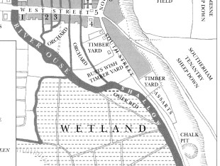
A map (from Colin Brent’s book Pre-Georgian Lewes) of 17th century South Street (detail below) shows the timber yards, chalk pit with wetland and osier bed (willows for basket making). Note the drain on the lower side of the osier bed where a cut would be made to canalise the Ouse in the late 18th century.
Maps from the second half of the 18th century show the street developed further and there is much more written evidence of the occupiers.
Click to enlarge
South Street developed considerably in the 19th century and censuses provide data on the inhabitants. The first pictures of the street were also produced in the 19th century.
At the beginning of the 20th century the street was home to many respectable working class families employed in local industries: on the river, in the ironworks, the gas works, railways and the cement works.
In the later 20th century the street was blighted by heavy traffic and dust from the Cement Works coated it white. Properties were relatively cheap and a few art students and others, who could not afford expensive houses, made the street their home.
From the 1980s the bypass and tunnel took away the traffic and, the cement works having closed, South Street became a desirable cul de sac in which to live. Gradually houses were improved and there were new developments, sadly few of architectural merit. However, In the 21st Century two architecturally distinctive homes appeared on the Street: No. 142, The Rusty House and No. 130, a Baufritz eco-house. (see section History of the Houses)
The Avalanche 1836
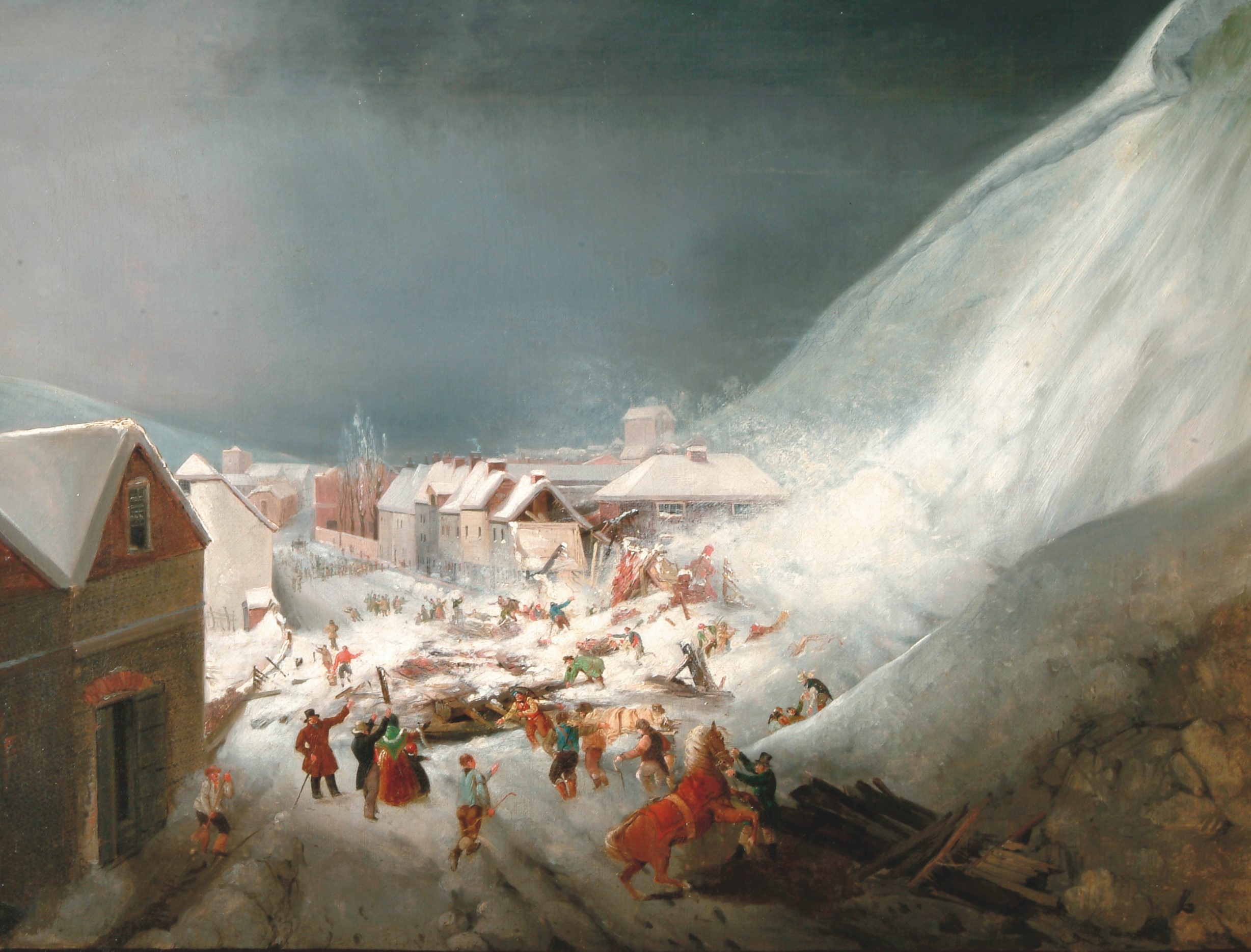
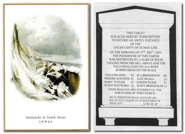
Britain’s worst avalanche occurred in South Street on the 27th December 1836. Severe snowstorms in the south of England led to a cornice some 10-15ft high building up on the cliffs above South Street.
On the evening of the 26th December snow broke away and fell onto Wille’s timberyard (the Deal yard) on the East side of the street, destroying a sawing shed. Warnings were given to South Street residents to move away from their homes but many refused to leave.
About 10am the next day, Tuesday 27th, Robert Higham, owner of the Schooner Inn (now number 128), saw the danger and tried to warn residents in the row of cottages opposite his house but ran for his life as an avalanche engulfed them. These cottages were owned by South Malling Parish for housing the poor and were known as Boulder Row. It was estimated that there were 40 residents altogether, but many had gone out to view the snowy scene. The snow fall completely overwhelmed the cottages, burying 15 people.
Rescuers dug out the dead and injured, who were carried to the workhouse (House of Industry, now nos. 37a-e), but eight died and seven were injured, some seriously.
Seven of the dead were buried in a single grave at South Malling Church, the eighth, presumably not being Church of England, was interred elsewhere. A memorial tablet to all eight victims was erected in South Malling Church. The site of Boulder Row became the Snowdrop public house – see Public House section for details.
Click images to enlarge